Translate

Friday, September 28, 2018

Coral Bay

East coast to West coast, Coolangatta to Coral Bay or however one chooses to call it, from one side of Australia to the other is a journey of some 4000kms. It represents approximately 10% of the total distance around the world and is at least fifteen hours flight time in the Bazflyer’s Comanche airplane.


The flight from Newman to Coral Bay occurred practically along the Tropic of Capricorn, the southernmost latitude where the Sun can be directly overhead. When the landing wheels alighted on the dirt Coral Bay airstrip it was the furtherest place West that ZK-BAZ had ever flown.


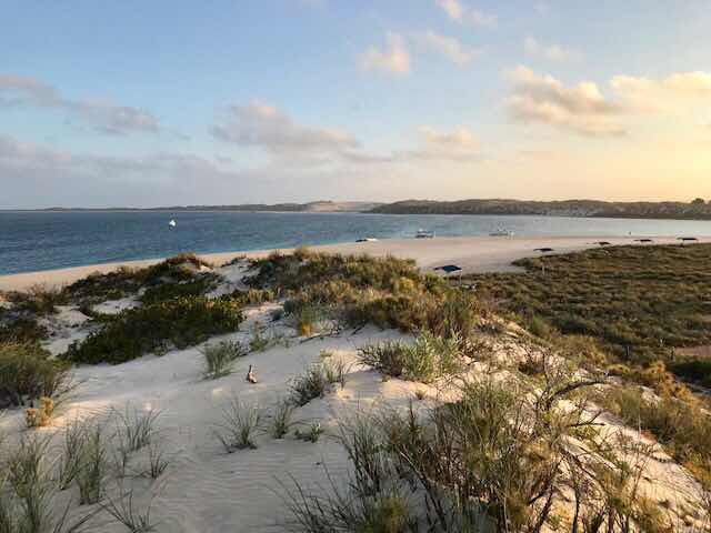
Coral Bay is a small settlement that lies protected from the Indian ocean by the Ningaloo Reef which is Australia's only fringing reef. This is where in contrast to other reefs the coral starts right at the water's edge. As a result the abundant habitat of fish and coral are very accessible. It’s also a place where one can to swim among giant Manta Rays....a prime reason for the Bazflyers visit. As a bonus we got to experience from close-quarters, a number of migratory Humpback whales with young calves that were making their way back to southern waters. https://youtu.be/0Um10GqmGpg


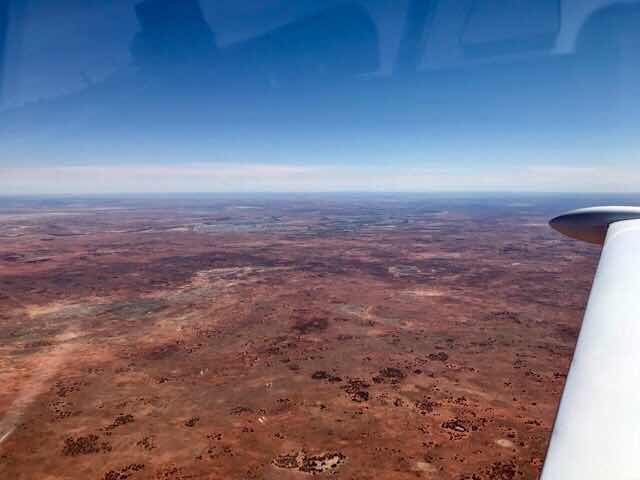
Flight route from Newman to Coral Bay on the West Coast of Australia. The northerly diversion from Newman was to look at Hickman Crater.  https://www.australiangeographic.com.au/topics/science-environment/2015/06/hickman-crater-in-western-australia/


Landing Coral Bay


The beach at Coral Bay


Newman

In so many ways almost everything about the great Australian Outback is big. The landscape is big with an endless horizon. The distances to just about anywhere are big. Stand in the middle of the Australian Outback and it is thousands of kilometres to the ocean in every direction. Even for the Bazflyers travelling at 300 km/hr in a Piper Comanche airplane, going from one place to the next can require hours of flying in a straight line.  


After taking off at Ayres Rock Airport where early morning temperatures were already well into the 30’s, (that’s Centigrade) and levelled off heading West at a slightly cooler flight altitude, the next place ahead of any consequence was four hours away. It was Newman. 


Now being in the great Australian Outback there just had to be something big about Newman. Yes, it’s Mount Whaleback mine, the largest single open-cut Iron Ore Mine in the World. It sure is an impressive big hole in the ground, currently 5.5km long and 2km wide. The ore mined at Mt Whaleback is transported 426km by rail from Newman to Port Headland on the West Coast. Not unsurprisingly, this is also big. It is the longest privately owned railroad in the Southern Hemisphere. The average train is nearly 3km in length, consisting of 4 locomotives, 268 Ore cars and 1 driver. Reputedly a train driver on the Newman to Port Headland line enjoys pampered working conditions and is paid $280,000 a year. Even that is big.


Four hour flight to Newman


Finals to land at Newman


Mt Whaleback Iron Ore open-cut mine


Even wheels are big


Tuesday, September 25, 2018

The Rock

It’s an ancient red sandstone monolith visible on the horizon many miles before its physical presence becomes truly apparent. Flying ever closer this dominating geological feature raises like a sphinx in a stark landscape. This is Uluru. 


Uluru has been an integral part of Aboriginal folklore for tens of thousands of years. One story says that none of the places we know existed until creator beings, in the forms of people, plants and animals, traveled widely across the land. Then, in a process of creation and destruction, they formed the landscape as we know it today. However, in the Bazflyers opinion and legend aside, this iconic feature is a mighty impressive ‘Rock’.


The flight time from Whyalla to Ayers Rock (Uluru) was 4.5 hours with an intermediary fuel stop at the opal mining settlement of Coober Pedy. Flight conditions in otherwise clear air were uncomfortable for most of the journey due thermal turbulence that could not be avoided even with a change in altitude. Flying the outback can sometimes be like that. The agitated air even challenged our scenic flight around ‘The Rock’ and adjacent Olgas also known as the Kata Tjua.


Flight Path to Uluru


The Rock


Olga’s


Dinner in the dessert 


Fields of Light


Saturday, September 22, 2018

Expecting the Unexpected

The onwards journey from Gold Coast to Whyalla was interrupted with an overnight stop at the inland farming town of Dubbo. Every time the Bazflyers fly over parts of inland Australia the vastness of the land never ceases to reinforce its unique impression. 


Configured in cruise flight, Comanche ZK-BAZ clips through the air at a pretty reasonable rate, like 300 km/hr. Even so getting to Whyalla, a flight across literally just a corner of Australia, required being in the air for over 6-hours.


Flight route from Gold Coast to Whyalla 


Riding along up there in a small plane looking in any direction, as far as the eyes can see, the landscape extends seamlessly to the horizon reinforcing a geographic fact that this is both the flattest and driest continent on the planet. Seen from the air, it’s a land of vast plains, sometimes the colour of dried blood, more often tawny like a lion’s skin. A land one can fly across without seeing a town or anything but the most scattered and minute signs of human habitation for vast stretches. But this is also a land of unexpected exceptions. Approaching Whyalla from the east and having crossed the northern remnants of the Flinders Range, the landform suddenly became a cultivated green expanse, fertile and prosperous. 


Time to start our descent for landing at Whyalla airport and a reunion with Comanche friends. Three Comanche airplane travelling together for the next month exploring the vastness of this huge land and along the way we’re guaranteed to come across many fascinating exceptions.


A vast and sunburnt land


A land of expected exceptions


Thursday, September 20, 2018

Point Danger

A short drive south of Coolangatta airport is a coastal headland that conveniently marks the border between New South Wales and Queensland. Captain Cook named the headland Point Danger when he first sighted it in 1770 as his ship Endeavour nearly hit reefs. 


Captain James Cook memorial and light house.


The elevated headland is a popular place to view migratory whales as they traverse the NSW coastline which was the case when the Bazflyers visited Point Danger. Whales head north to the warm coastal waters of Queensland and the Coral Sea to mate and give birth from late April to August, and then from September to November they return, often close to the coast, on their way back to southern waters.


Southerly view from Point Danger.


A number ofl memorials grace Point Danger and among these is a memorial to the lives lost when on 24 May 1943 the Australian Hospital Ship Centaur was torpedoed and sunk by enemy action with the loss of 268 non-combatant lives. Only 64 survived. This little known WW2 episode was closed only in 2009 when the sunken wreck was discovered out to sea off Point Danger.


This newly completed and rather unique pod-house takes advantage of an elevated site on Point Danger.


Its Official

The Tasman Sea separates Australia and New Zealand. It is a marginal area of the South Pacific Ocean and measures about 2,000 kilometres (1,200 NM) across. The sea was named after the Dutch explorer Abel Tasman, who was the first recorded European to encounter New Zealand. The British explorer CaptaIn Cook later extensively navigated the Tasman Sea in the 1770s as part of his first voyage of exploration. A flight across this stretch of water is required each time the Bazflyers move Comanche ZK-BAZ between New Zealand and Australia. On this occasion it was the 14th such BAZ flight in the past eight years. It was also the first time the Bazflyer have done this flight direct between the two countries without stopping at Norfolk Island or Lord Howe Island.


It’s official then, 7 hours 4 minutes at an average ground speed of (303 km/hr) 165 kts. 

http://mrcaviation.blogspot.com/2018/09/baz-heads-offshore.html


Departure out of Kerikeri was was straight into the murk and rain which was pretty much our fare for about an hour before BAZ emerged into forecast blue skies. 


The flight route took us about 120 NM north of Lord Howe Island and nearby Middleton Reef. This fascinating ocean feature is the top of a huge ocean mountain and is rarely seen or visited. Conditions and tides were fortunately in alignment for a viewing as the Bazflyers passed by. https://m.youtube.com/watch?v=0ZJkSXmnxvQ&feature=youtu.be